Oroville Dam
Information contributed by Nick DeBar, Lisa Maddaus and Dave
Stoughton
from a report dated December 8, 1994
and from a report by Ben Au, Pauline Cheng, and Corrine Tan dated
December
15, 1994.
Oroville Data Links
CDEC
Station-Current Sensor Data
USGS Hydrologic Data Report
-
1994
-
1995
Return to top of
Oroville Dam home
page
Return to Dams first page
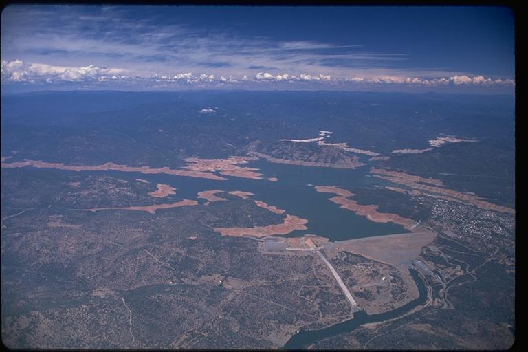
Oroville Dam and Lake during drought

Oroville Dam and Lake

Oroville Dam General Information
Dam
Location/Directions
Ownership/Operators
Tour Information
Dam Location/Directions
Oroville Dam is located on the Feather River, nine miles east of
Oroville,
CA, located in the Sierra Nevada Foothills 75 miles north of
Sacramento
and 60 miles south of Redding. The coordinates of the dam
are 38°
35.3' North Latitude and 122° 27.8' West Longitude.
From Sacramento, travel north on Interstate Five. In approximately three miles, turn off on Highway 99 north towards Yuba City. After 13 miles, take Highway 70 north towards Marysville. Oroville is 48 miles north on Highway 70. Take the second exit off the highway at Oroville Dam Boulevard (also Highway 162). Turn right on Oroville Dam Blvd. heading due east. Follow Oroville Dam Blvd. through town and in approximately nine miles the spillway and dam will be visible on the left hand side. Climb the hillside to the right of the dam, turn left at the stop sign and drive on top of the dam for spectacular views. One can also go straight through the stop sign and follow the green painted roadway stripe up to the Visitor's Center.
From Redding, travel south on Interstate Five. In Red Bluff, turn onto Highway 99 south towards Chico. Approximately eleven miles past Chico, take Highway 149 which joins with Highway 70 to Oroville. Take the Oroville Dam Blvd. exit. Turn left onto Oroville Dam Blvd., heading due east. Follow Oroville Dam Blvd. to the dam and use the directions above to get to specific dam facilities.
Ownership/Operators
Oroville Dam is currently owned and operated by the State of
California
Department of Water Resources.
Tour information
For a tour of the Edward Hyatt Powerplant and/or the Feather River
Fish Hatchery facilities contact John Ford at (530)534-2306.
Tours
are scheduled on a first come-first serve basis, and generally
given in
groups. Tours are free of charge. Allow two hours for
the tour
of the dam facilities and one hour for the fish hatchery.
Oroville Dam Design and Construction:
Construction
type
Construction
date
Dam
The Hyatt Powerplant is the largest and has 6 turbine generators- 3 conventional and 3 reversible. The 6 generators are capable of producing 67,788 megawatts of electricity. Thermalito Powerplant has 4 generators- 1 conventional and 3 reversible. 119.6 megawatts can be produced at Thermalito. The Thermalito Diversion Dam can produce 3.4 megawatts of electricity (Ford, 1964)
The energy produced from these plants is partially used to offset the operating costs. Currently, Southern Cal Edison has contracted with DWR to purchase excess electricity.
Oroville Dam Current Uses and Operations:
Reservoir Background
Reservoir
Storage/Flood
Control
Water Deliveries
Fisheries Flows
Recent operating
challenges
Concerns for
future operations
Reservoir Background
In 1940, studies were done to determine where to construct a dam
along
the Feather River to act as a major water storage facility for the
California
State Water Project. In 1960, voters approved a bond issue
to begin
construction of Oroville Dam. The earthen dam was chosen for
economic
feasibility. The supply of tailings was hauled in by the
railroad
from impervious core material that could be found less than ten
miles away.
Workers then added 23 miles of railroad to move the existing
railroad tracks
out the the path of the reservoir. The relocation of the
railroad
required building three new bridges and five tunnels.
Actual
work on the dam began in 1961. The two diversion tunnels and
initial
dam were completed before the winter season of 1964-65. The
embankment
of the final dam was completed in 1967, and the spillway was
finished in
1968. The power plant and cleanup of the site were finished
within
the next two years.
Two diversion tunnels were constructed for diverting water around the construction area. Diversion #2 is now used as an outlet for the water being utilized by the underground power plant. The 35 foot diameter size of the tunnels was chosen to withstand the flows of previously recorded floods on the Feather River. After final completion of the dam in 1967, Diversion Tunnels #1 and #2 were plugged. They excavated a system of tunnels for the powerhouse, some of which connected to Diversion Tunnel #2.
Reservoir
Storage/Flood
Control
The Oroville-Thermalito Complex is a peak operating
facility.
There is coordination between releasing water and producing power,
where
releasing water takes precedence. During normal operation, a
24-hour
supply of water is squeezed both plants during a peak 6-10 hour
window
of the day when power production is most needed. The water
is then
stored in Thermalito Afterbay, a holding reservoir located beneath
the
Thermalito facility.
A primary purpose of the Dam was to provide flood control. As the lake fills during heavy rains or large spring snow melts, water is carefully released to prevent flooding downstream, saving both lives and costly property damage (DWR, Oroville-Thermalito, 1991).
The dam mainly protects Butte County and area along the Feather River from large flooding. Floods occurred every few years, costing the residents of the area millions in damages. For example, in December of 1955, the largest flood to date caused damages along the Feather River in excess of $82 million (Report on Reservoir Regulation for Flood Control).
Water Deliveries
Oroville Dam is a major water storage facility for the State Water
Project (SWP). The dam releases an average of 2.8 million
acre feet
(MAF) of its total capacity of 3.5 MAF. Water deliveries
made to
Butte and Plumas County in northern CA and to the lower San
Joaquin Valley
(Kern, San Bernadino, King and Riverside Counties) in southern CA
are mainly
to irrigate agricultural crops. Eighty-five percent of the
water
demand in the San Joaquin Region is for irrigation with
twenty-nine percent
of the water supply coming from imported State Water Project (SWP)
deliveries
from Lake Oroville. This imported water is crucial to
prevent groundwater
supplies from becoming severely depleted. Additional water
supplied
by Lake Oroville is delivered to counties to the South Coast
Region.
Some of the water is used for environmental concerns. The water is used to maintain the Feather and Sacramento Rivers and the San Francisco-San Joaquin delta. The water for the Delta is used to increase the water quality by lowering the salinity levels. Additionally, the extra water helps restore the habitat for the Delta Smelt and Chinook Salmon (DWR, Bulletin 160, 1993).
Fisheries Flows
The construction of the dam made the upper portion of the Feather
River
inaccessible to migrating salmon and steel head trout who used it
for spawning
grounds. To make up for the lost spawning area, the Feather
River
Hatchery was constructed.
Funded by DWR and the Department of Fish and Game (DFG), DWR maintains the facilities while DFG staffs and operates it (Ford, 1964). It can accommodate 9000 adult salmon and 2000 adult steel head. The incubator can hold 20 million eggs and 9.6 million fingerlings can be reared in the 8 concrete raceways (DWR, Bulletin 200, 1974).
Historically, the majority of the steel head and salmon spawn below the Oroville Dam. Currently, approximately 20% spawn in the hatchery and 80% spawn downstream (Ford, 1994). The hatchery has been very successful due to the carefully monitored flow of water.
Recent operating
challenges
To keep the recreation areas fully functional with the low water
levels
due to drought. Numerous faults were mapped in the
foundations of
the Oroville Dam and Hyatt Powerplant. However, none
appeared to
be significantly threatening since displacement along the faults
would
be minimal and unlikely to occur.
Landslides around the reservoir rim have occurred since Lake
Oroville
has been in operation. These landslide do not pose a threat
to the
freeboard of the dam or the safety of the public.
Concerns for
future
operations
The Department of Water Resources signed contracts for the
eventual
delivery of 4.23 million acre-feet (MAF) from Lake Oroville.
Currently,
SWP facilities provide an average of 2.8 MAF with the potential of
providing
3.4 MAF by 2010 with existing facilities (additional facilities
could provide
4.2 MAF).
The main concern for the future operations of Oroville Dam lies in its ability to make efficient water releases to meet increasing water demands. Currently, San Jouquin Valley farmers are receiving 100% of their contract entitlement in non-drought years. However, the South Coast Region is only receiving 60% of its entitlement in wet years (DWR, Bulletin 160, 1993). Based on the 1990 census, the South Coast is projected to increase by 25 million people by 2020, thus increasing water demand by 1.5 MAF. A net water supply deficit of 3.3 MAF to 4.2 MAF is expected in year 2020 (DWR, Bulletin 160, 1993). To meet these shortages, it will require a more efficient operation of water storage facilities.
However, governmental regulations now require that more water
supply
is dedicated to environmental needs. Therefore, one the the
future
operating challenges for the Oroville Dam is to honor the signed
contracts,
while maintaining the needed water supply to meet environmental
needs.
Return to top of
Oroville Dam home
page
Return to Dams first page
Website designed by Nova Clemenza with additions
from
a website designed by Wilson Lew.