New Bullards Bar Dam Web Page

The creators of this web page, Bryan Jones and Jason Pack, would like to welcome you to this dam web page. New Bullards Bar Reservoir is a beautiful lake nestled in amongst rolling hills and dense pine trees in the Sierra Nevada mountains. It is just off of Highway 49, a scenic route through historic Nevada City and Downieville. The area is renowned for its rustic beauty, gold mining roots, and superb mountain biking. It is a perfect setting for that weekend get away, or those Sunday drives.
Dams provide a variety of functions for the benefits of mankind. They provide reservoirs that can be used to supply water during terms of minimal water fall, they provide recreational areas for people to enjoy, they can provide clean power to the power grid if a hydropower plant is set up on the dam, and they can limit the amount of water flowing down rivers during the runoff season in order to prevent downstream damage to houses, farms and people.
The purpose of this dam web page is to provide the user with information about New Bullards Bar Dam. We hope you find this informative, interesting, fun, and useful.


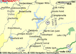
Latitude 39’23’34", Longitude 121’ 08’ 25", Yuba County. Located on the west side of the Sierra Nevada Mountain Range in the State of California. Nearest big Cities include Nevada City and Marysville. Bullards Bar is located approximately 21 miles north of Nevada City off of Highway 49. Elevation of the area 2,000 ft. For exact dam directions, please visit www.mapquest.com


Maximum contents: 966,103 acre-ft on June 12, 1982 elevation 1956 ft
Minimum contents: 178,230 acre-ft on December 29, 1980 elevation 1700 ft
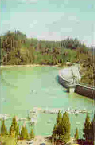
Bullards Bar Dam is the 2nd tallest dam in California and 5th tallest in the United States. It stand 645 ft above the canyon floor.
Drainage Area: 489 square-miles
Dam Construction/Specifications
The reservoir is formed by a concrete-arch dam with a concrete-sidehill spillway. The spillway is controlled by three 30 ft by 53 ft radial gates. Usage capacity, 727,380 acre-ft between elevations 1,732 ft where the minimum power pool is and 1955 ft where the normal gross pool occurs. Dead storage is 233,920 acre-ft. The total capacity at normal gross poll is 961,300 acre-ft. The Dam stands 645 feet above the canyon floor and was completed in 1971.
Bullards Bar dam is a hydro-electric dam and is operated by Yuba County Water Agency. They manage the storage so that recreation access to the reservoir is never restricted.
|
Maximum Discharge |
163000 AF |
|
Maximum Storage |
960000 AF |
|
Normal Storage |
730000 AF |
|
Surface Area |
4790 acres |
|
Power Output from Hydropower |
361,900 KW |
|
Drainage Area |
489 square miles |
Bullards Bar Reservoir is a working part of the Yuba River drainage basin. This basin lies entirely within Sierra and Nevada Counties and is drained by three major tributaries, the North Yuba, Middle Yuba, and South Yuba Rivers. The North and Middle Yuba Rivers join about 5 miles downstream from New Bullards Bar Dam to form the Yuba River. The confluence of the Yuba and South Yuba Rivers is at the upper end of Engelbright Reservoir. The basin is bounded by the Feather River basin on the north, by the Little Truckee River basin on the east, and by the Bear River and American River basins on the south. The headwater regions are located in the Sierra Nevada snowfields at elevations ranging up to 9,100 feet above sea level.
Jurisdiction: Yuba County Water Agency
Storage began in January of 1969.
The North Fork of the Yuba River is the inflow to Bullards Bar Reservoir. Water is released at the Dam to go down stream and join flows from the Middle and South Forks of the Yuba River and are eventually held back by the Engelbright dam. From the Engelbright dam some water is diverted to a North and South Irrigation ditch but the majority continues down stream through Marysville and joins up with the Feather River. Bullards Bar Reservoir provides flood control space between the dates of September 15 and May 31 of each year. There is 170,000 acre-ft of flood control storage between October 31 and March 31. The flood control storage ramps up and down between September 15-October 31 and March 31- May 31.
The reservoir is 16 miles long and has 60 miles of convulted shoreline with a total of 4,700 surface acres. Pine, fir, oak, magrone and dogwood trees line the banks of the reservoir. There are Kokanee Salmon, Rainbow Trout, German Browns, Largemouth, Smallmouth and Black Bass, Crappie, Catfish, and Bluegill that inhabit the waters, along with other nonnative species. The National Forests around the lake are inhabited by numerous amount of wildlife along with native grasses, conifer and deciduous trees.
The Yuba River Basin has experienced frequent floods. The most destructive recorded floods on the Yuba and Feather Rivers occurred in 1950, 1955, 1986, 1997. Major storms resulted in record flows, which eroded levee embankments and exceeded design levels downstream of New Bullards Bar Dam and Oriville dam. These floods inundated urban and agricultural lands, forced damage and loss of life. Investment costs to improve flood control are estimated at $28 million.
All camping is by reservation only! There is a two night minimum. Mastercard and Visa are excepted at the time of reservation and reservations start each year on January 2nd. Camping permits must be picked up at the Emerald Cove Marina and people camping without a permit will be cited. There are only about 60 sites.
There are 4,700 surface acres for boating. The only access to the lake is 2 boat ramps. Rangers warn that during heavy run-off to be on the lookout for objects floating in the water. All vessels must be operated in accordance with federal, state and local laws.
For the fisherman, there are Kokanee Salmon, Rainbow Trout, German Browns, Largemouth, Smallmouth and Black Bass, Crappie, Catfish, and Bluegill. Bullards Bar has a reputation as having the best Kokanee Salmon Fishing in California.
For rules and regulations for fishing on the lake please check the California Sport Fishing Regulation as they change annually.
As of 5/25/99
Trout & Salmon: Open season all year. Limit five
Bass: Open season all year. Limit five bass with minimum length 12 inches
Crappie: Open season all year. Limit twenty-five
All other species may be taken in any number and at any time of the year by angling.
Also check this website to see how the fish are biting and what tackle/methods will be used.
Average Water Temperature:
Spring: 65 degrees
Summer:80 degrees
Fall: 68 degrees
Average Air Temperature
Spring: 72 degrees
Summer: 90 degrees
Fall: 72 degrees
Emerald Cove Resort & Marina P.O. Box 1954 Nevada City, CA 95959 (530) 692-3200
Yuba County Water Agency 1409 D Street. Marysville, CA 95901 (530) 741-6278
United States Forest Service N. Yuba Ranger Station (530) 288-3231
Period of Record from January 1969 to present
Current River and Reservoir Conditions
Current Streamflow Conditions North Yuba River
Storage and Flows for current and past years for New Bullards Bar
Other Fun Stuff to Look AtCalifornia Reservoir Information
http://www.anglenet.com/web/lakes/bullards
http://s101dcascr.wr.usgs.gov/rt-cgi/gen_stn_pg?station=11413000
http://www50.spk.usace.army.mil/cespk-pd/yuba/pb1.html
http://water.wr.usgs.gov/data/94/1k/1k11413515.sc4.html
http://ca.water.usgs.gov/data/94/1k/1k11413515.sc4.html
http://ca.water.usgs.gov/data/95/sw/sw11413510.sc4.html
http://ca.water.usgs.gov/data/96/11413510.html
http://ca.water.usgs.gov/data/97/11413510.html
http://www.jerrysguideservice.com/index.html
http://elib.cs.berkeley.edu/cgi-bin/illus_dams?Elib+dams+1034-000
http://www.roomsplus.com/campgrnd/ca/y/cay10492.htm
http://elib.cs.berkeley.edu/kopec/b17/html/1034-000.html
http://elib.cs.berkeley.edu/kopec/b17/html/50.html
http://elib.cs.berkeley.edu/kopec/b17/html/ocr-50.html
A Plan for the Early Development of Water and Power Resources in the Yuba, Feather and Upper Sacramento River Basins a part of the later Report on a statewide development Plan entitled "An Approach to a California Public Works Plan" Submitted to the Assembly Interim Committee on Conservation, Planning and Public Works. Sept 20, 1958.
22 Westside Rivers, Wild & Scenic River Study Report Draft Environmental Impact Statement, Tahoe National Forest, Bureau of Land Management Government Documents
Flood Plain Information Feather and Yuba Rivers Marysville-Yuba City, California, Prepared for The California State Reclamation Board and Butte, Sutter, and Yuba Counties by Corps of Engineers, U.S. Army, June 1968.
Page created by Bryan Jones and Jason Pack
for ECI 155, Professor Lund, UC Davis