Folsom Dam
Information contributed by Jason Shykowski and Matt Hardigree from
a report dated November 25, 1994
and from a report by Diane Gentry dated November 15, 1995.
Folsom Data Links
CDEC
Station-Current Sensor Data
USGS Hydrologic Data Report
- 1994
-
1995
Return to top of Folsom Dam
home page
Return to Dams First Page
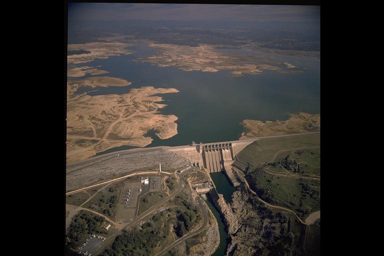
Folsom Dam and Lake during drought

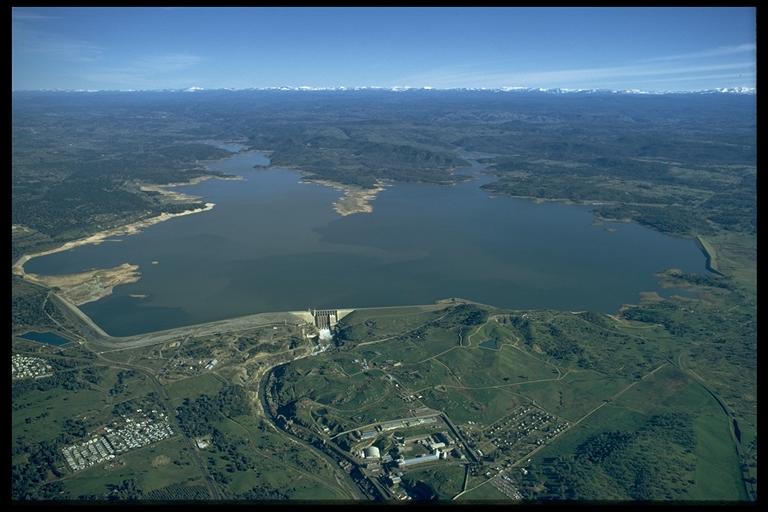
Folsom Dam and Lake

Folsom Dam General Information
Dam
Location/Directions
Ownership/Operators
Technical Contact
Tour Information
Dam Location/Directions
Folsom Dam and Reservoir is located downstream of the confluence of
the north and south forks of the American River, near the City of
Folsom.
Folsom Dam is located approximately 20 miles northeast of
Sacramento.
The coordinates of the dam are 38° 42.5' North Latitude and
121°
9.4' West Longitude.
From Sacramento, take highway 50 east to Folsom Blvd. exit. From the off ramp, turn left onto Folsom Blvd. Continue on Folsom Blvd. until reaching Leidersdorff St. and turn left. At the traffic signal of Liedersdorff St. and Riley St.; turn left onto Riley St. and cross over the Rainbow Bridge. Next, turn right onto Folsom-Auburn Rd and proceed for about 1.5 mile, then turn right onto Folsom Dam Rd. The dam is the second gate to the right. If this gate is closed, use the first gate on the right after making the right turn onto Folsom Dam Rd.
Ownership/Operators
The dam was constructed by the US Army Corps of Engineers, but is
currently
owned and operated by the US Government Department of the Interior,
Bureau
of Reclamation.
Technical Contact
Bill Sanford, CE, (916)989-7217.
Tour information
Alas, USBR no longer gives tours.
Folsom Dam Design and Construction:
Construction type
Construction date
Dam
Folsom Power plant is located at the base of the Folsom Dam.
The water is delivered to the power plant via the three
penstocks.
Each penstock has a flow of 2300 cfs between the reservoir and through
turbines. The water has a vertical drop of approximately 300
ft.
The generators were built in 1956 and have a combined capacity of 198
Megawatts.
On average, the power plant produces about 10% of the power used in
Sacramento
each year. (Baptista).
Folsom Dam Current Uses and Operations:
Reservoir Background
Reservoir Storage/Flood
Control
Water Deliveries
Water Transfers
Fisheries Flows
Recent operating challenges
Concerns for future
operations
Reservoir Background
As settlers began to move west, away from the crowded cities in the
eastern portion of the United States, the Central Valley became a
stopping
point on the trails to Los Angeles, to San Francisco, and to the
Northwest.
Due to frequent flooding, the soil was very fertile and some people
began
settling and farming the land in the Central Valley (Devereux, 1).
The largest boom in development and growth in this area occurred after gold was discovered in 1849 at Sutter’s Mill, just east of the Sacramento foothills. The era of gold mining reached its peak in the mid to late 1800’s, finally ending in the late 1800’s, when the Sawyers Decision outlawed hydraulic mining. By this time, dredge trailings produced by the hydraulic mining industry had already clogged the valley's river system, further exacerbating the frequent flooding of this inland sea (Devereux, 1).
Farmers, merchants, and residents of the fertile valley began to evaluate their situation and contemplate ways to keep the river from overflowing their banks and flooding their homes and farms. A piecemeal flood control system consisting of levees, embankments, and channels was constructed, with each farmer or landowner working independently to protect their land from the inundation of the flooding rivers. As one would expect, this unorganized system provided little protection against the larger flood events which occurred in the late 1800’s (Devereux, 1).
In the aftermath of these failures, some people began to realize that if they worked together instead of independently, they could develop a more comprehensive and effective plan for the flood control of the river. However, no coordinated effort occurred until the State of California (by means of the Reclamation Board) and the federal government (by means of the Corps of Engineers) became involved. From the efforts of these two agencies, Congress authorized the Sacramento River Flood Control Project in 1917. This project envisioned a system of levees along the river channel, with large overflow channels connected to the rivers via a series of weirs and bypass channels to safely move any excess of the river's capacity to the Delta.
Folsom Lake impounds the runoff from 1,875 square miles of mountainous terrain. The lake is a source of flood control, water supply, electric power, and recreation. The new Folsom Dam is a product of the Central Valley Project (CVP). Final completion of the dam was in 1956. Although, by the end of 1955 the dam was able to store its first full capacity reservoir and produce electricity. The Folsom Dam was constructed to prevent flood damage. In 1986, the lake reached an all time high inflow of 813,165 cfs and with an outflow of 130,000 cfs only minor flooding resulted.
Reservoir
Storage/Flood
Control
During the flood season, Folsom Dam and Reservoir is operated in
according
to criteria that has been promulgated by the Secretary of the Army
(Devereux,
8). There are two criteria. The first is a design release
of
115,000 cfs from the reservoir during a flood event. The second
is
400,000 acre-feet of storage is dedicated to flood control. In
the
early 1950’s when these criteria were developed, this dam was expected
to provide the Sacramento area with a 250 year level flood
protection.
Due to more and better data, the Corps of Engineers now determine that
the dam will only provide for a 63 year level protection (Carlson, 2).
Flood control capacity could be increased if releases of greater than 115,000 cfs were allowed, but the levees on the American River are not capable of handling the greater flow for any extended time period.
Water Deliveries
Folsom Dam moderates winter and spring flows to the American
River and releases water to the American River during the summer and
fall.
The four main water users are the city of Roseville, the North Fork
Ditch
(SJSWD), the city of Folsom and Folsom Prison, and the pumping
plant.
The water supply system is meant to provide for a maximum of 65 cfs for
the Natomas Pipeline and 250 cfs for the North Fork Pipeline.
The largest percentage of water demand for Folsom is agriculture (CA Water Plan, 130). Crops grown include alfalfa, sugar beets, beans, rice, cotton, almonds, apricots, asparagus, grapes, melon, oranges, peaches, pears, plums, tomatoes, and walnuts. Rice accounts for 23% of the total acreage used for farming, which is also a very water intensive crop.
Urban water uses include residential, industrial, commercial, and government uses. Residential water use accounts for more than half of all urban water use. Landscaping accounts for about 75% of all residential water use (CA Water Plan, 130).
Water Transfers
The Sacramento River Flood Control Project is complemented by the
Central
Valley Project (CVP), a system of dams and reservoirs. The
CVP is a system by which water is stored and distributed throughout the
Central Valley. The CVP also generates hydroelectric power for
the
Central Valley. The primary components of the CVP are a series of
multi-purpose dams and reservoirs in the foothills which collects
winter
rains and spring runoff for use in the summer and the fall. These
reservoirs are also connected to the existing flood control
system.
They are used during the flood control season to provide storage space
for the runoff that is generated by large flood events, in addition
they
provide water supply, recreation, and power (Devereux, 2). The
CVP
stores and transports surplus water from the American, Sacramento, San
Joaquin, Stanislaus, and Trinity River Basins in northern and central
California,
and that water is used primarily for irrigation in the Central Valley
(Folsom
Brochure). From the perspective of residents in the Sacramento
area,
the most prominent feature of the CVP is the Folsom Dam and Reservoir.
Fisheries Flows
A portion of the supply in Folsom Lake must be set aside for
environmental
use, the second largest percentage of Folsom’s water demand. (CA Water
Plan, 130). The CVP Improvement Act (CVPIA) of 1992 reallocated
1,000,000
acre-feet of supplies from its reservoirs for fish and wildlife (CA
Water
Plan, 2), thus increasing the amount of water from Folsom to be used
for
environmental purposes. Environmental issues include (Folsom Dam
& Reservoir, V-18)
Recent operating
challenges
The main goal of the operational plans is the upkeep of the facilities
in conjunction with environmental concerns and regulations. These
concerns are mainly the survival of the winter-run Chinook
Salmon.
The winter-run Salmon have declined from a mean of 86,000 fish during
the
period of 1967-69 to 2,400 fish during the period of 1982-87 and to 500
fish in 1989-90. The Salmon are now protected under Federal and
State
Endangered Species Acts. Temperature is an important
environmental
variable affecting fish growth. Thus, in 1993 a Temperature
Control
Device (TDC) was proposed to be located on the face of the dam at the
penstock
intake. This TDC would improve the temperature of the water by
releasing
water from different levels of the dam, then into the power house to
generate
electricity.
Concerns for future
operations
Silting within the dam may present future concerns. The build
up of Calcium Carbonate must be attenuated in the pipes every 2-3 years
to prevent clogging. Dynamic compaction of soils beneath the
Folsom's
auxillary earth dam was necessary to correct for dilation.
There possibly exists a low estimate of the 100-year flood from
1949.
Currently, the dam can manage a flood severity near that of a 63-year
flood.
By adding more flood storage capacity to the reservoir, the water
supply
and the power plant production would decrease.
Return to top of Folsom Dam
home page
Return to Dams first page
Website designed by Nova Clemenza with additions
from
a website designed by Wilson Lew.